Barbara E. Mundy, Donald and Martha Robertson Chair in Latin American Art History, Tulane University
Mexico
England?, 18th century?
Collage: brown wash with pencil, engraving. Mounted on page 134 in volume 6 of M.C.D. Borden’s extensively extra-illustrated copy of: Horace Walpole and his world edited by L. B. Seeley London: Seeley, Jackson, and Halliday, 1884 Folio 225 884S Copy 2 Lewis Walpole Library, Yale University
When Cynthia Roman, the curator of the Lewis Walpole Library collection, sent me a photo of this image and asked me to write a blog, it was a welcome assignment. Over decades of looking at printed maps, I found this one both deeply familiar and utterly strange. A collage, certainly, but where did the pieces come from? How much was borrowed, how much invented? And what scholar–particularly the art historian–doesn’t welcome a little bit of armchair detective work?
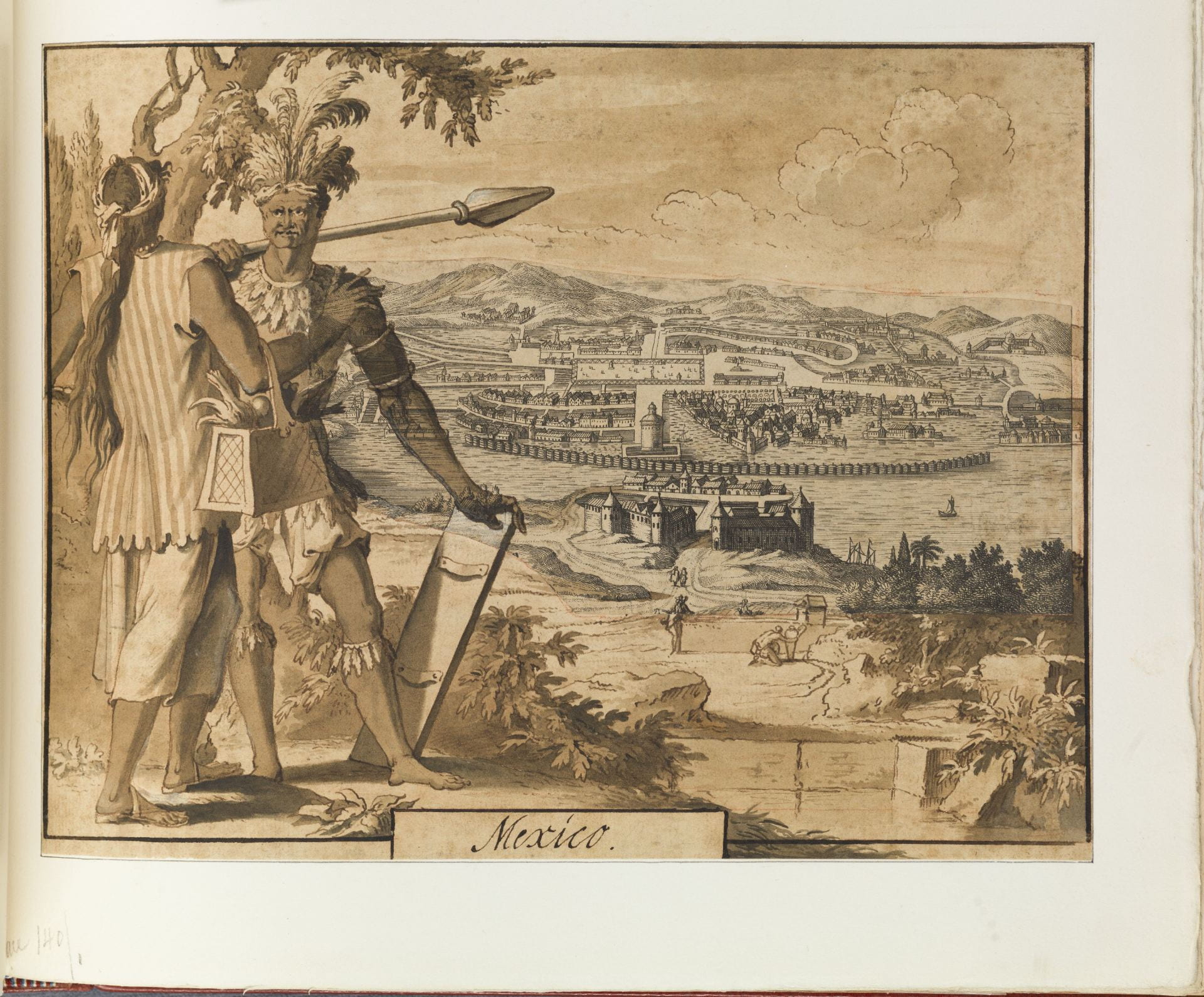
Mounted in a 19th-century publication on Walpole, the laid paper sheet contains a cut-out and pasted-down map of the Aztec city of Tenochtitlan, now Mexico City, at center, surrounded by a painting in wash. The painted surround was intended to seamlessly extend and add to the map’s imagery, and likely once had the same grey tones of the engraved map at center. But today the additions are shades of brown, making the contrast between printed call and painted response more evident, and heightening the artificiality of the painter’s conceit.
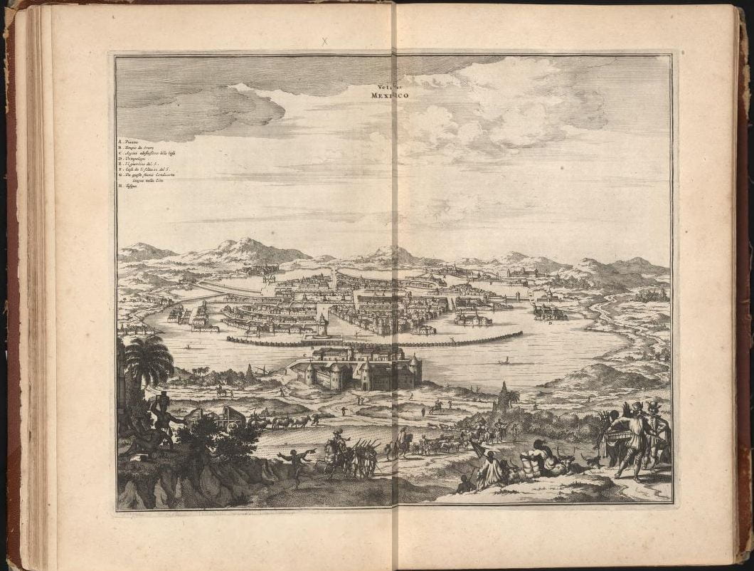
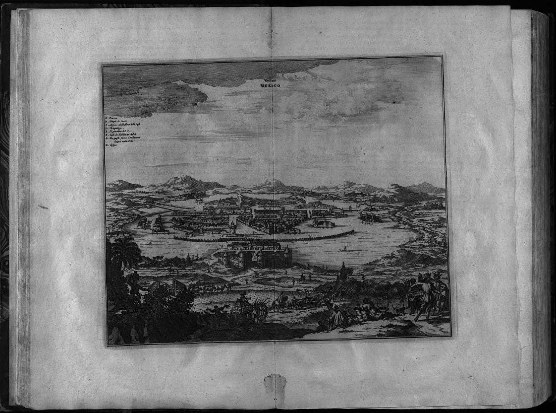
“Vetus Mexico” in Arnoldus Montanus De Nieuwe en onbekende weereld: of Beschryving van America en’t zuid-land Amsterdam, ca. 1671 Courtesy of The Library of Congress (https://www.wdl.org/en/item/518/) [image edited at LWL to combine pages for spread]
The cut-out map at center adopts an elevated perspective, to show Mexico City as Aztec capital before its invasion by Spaniards in 1519-21. It is a map with a long genealogy. This one is the direct offspring of an engraved map titled “Vetus Mexico,” included in Arnoldus Montanus’s De Nieuwe en onbekende weereld: of Beschryving van America en’t zuid-land, published in Amsterdam in about 1671.
John Ogilby
America, Being an Accurate Description of the New World, Printed by the author, 1671 Courtesy of The Smithsonian Libraries
(https://library.si.edu/digital-library/book/america00ogil)
The same plates were used in the English translation, America, Being an Accurate Description of the New World, by John Ogilby in 1671. Montanus’s engraving was copied by other publishers through the 18th century, including the one who created the map used in the collage. Novel are the two figures at left: an “Aztec” warrior (as imagined in the 18th century) gazes towards the viewer, as his companion, seen largely from the rear, gestures to the right and brings attention to the urban view. The vertical stripe of the figure’s tunic parallels that of the image’s frame, locking it into the composition.
By the 18th century, the many copies of “Vetus Mexico” granted it the authority that comes with ubiquity. The prototype was a map accompanying the letters written by the Spanish conquistador Hernán Cortés, published in 1524. When the 1524 map was set into a text that offered vivid descriptions of the city’s complex lacustrine environment, its temples and its markets, it came to carry the same truth value as did Cortés’s eyewitness account. Later editions of the map were also paired with textual descriptions, yielding much the same truth value.
Mexico (detail) The Lewis Walpole Library, Yale University
The creator of this image allowed the map of the Aztec city to inspire the imaginative projection of Aztec peoples, seen in the two figures on the left. Here, the artist’s imagination has been fed by images of Amerindians that circulated in books or as single-sheet prints, particularly the engraved plates that appeared in Montanus’s, and later Ogilby’s, work: the feathered headdress and skirt; the arm and leg bracelets; the shield and spear; the bare chest and feet. By the 18th century, these items, many quite fanciful, were standard repertoire for depictions of Amerindians. Less expected is the modest dress of the accompanying figure, whose muscled arm and confident wide-fingered gesture suggests male rather than female. This gender ambiguity may be due to the painter’s lack of skill, registered in the face of the “Aztec” warrior, where an initial three-quarter’s view seems to have been extended to a frontal one. The painter avoided rendering the face of the warrior’s companion entirely.
While the cutting and pasting seem like child’s play, the figures a game of dress-up on display, the image is unsettling to me. My response is not the recoil of the bibliophile when scissors dismember the volume, nor is it the scholar’s distaste for the fantasy over the factual. Indeed, the art historian in me sees much that is familiar, which presumably should be comforting.
The pairing of a city view in the background with foreground figural “types” found widespread expression beginning in the 16th century. Braun and Hogenberg’s Civitates Orbis Terrarum published in many editions across the 16th and 17th century offers the most prominent examples of setting the complexion and habits of urban residents against the background of a city view.

Mexico Regia et Celebris Hispaniae Novae Civitas
in
Georg Braun and Frans Hogenberg
“Civitates Orbis Terrarum”
Cologne, 1572
Folio 49 3675 vol. 1 The Lewis Walpole Library, Yale University
What is unsettling is the creator’s confidence in the assignment of types to place. There’s the confidence to recycle a centuries-old trope of certain bodies belonging to certain places. And in the cutting, pasting, and quick strokes of wash on the page, I see the creator’s visual assertion of a powerful control over bodies and places. The imaginary bodies are like pieces in a game of chess: the “Aztec” warrior here, the pawn/peon by his side. It would be child’s play, except that we live today in the aftermath of such confident assignments. These assignments were grounded in 16th- century notions that human bodies are constituted by places of origin, that stars and climate have a determinative effect on who a person fundamentally is. Such an ideology was adopted and adapted by the nation-state, to tether people to place, and naturalize that connection through citizenship. It’s an ideology that is tested and contested in our present moment, as real life people, many of them of Amerindian descent, dislocated by political violence and climate change, are uprooting in a desperate search for a hospitable place. The ideology articulated on this page, with bodies assigned to a place and locked into a landscape, finds new life in the closing of borders. While an old collage cannot be blamed for today’s mass deportations and forced repatriations, this well-educated and affluent creator’s confident cutting, his or her easy assignment of fantastic people to places on the map needs to be taken seriously if one is to ponder the shape of the modern world and imagine the future desired for it.