Carlene Miller, Graham Harboe, Sunny Park
Urban Squares
In many ways, the urban square is an idealized American version of the Roman public forum. In theory, it is a place open to all and a place to gather; it is a place to be seen and a place to be heard. In New Haven, the importance of the urban square has long played a key role in the city’s planning. The first urban square in New Haven was laid out as the central unifying element of the nine square gridiron plan.. As the city expanded, urban squares were planned and included at the inception of these new communities. Urban squares are a vital part of the city’s infrastructure; they are places for political activism, escapes from the urban environment, and aids to public health.
New Haven Green

This picture of the New Haven Green from 1938 showcases its place as a truly civic piece of infrastructure. Not only does it include two of the three churches of the Green, but it shows the vibrant downtown retail, business, and government buildings that surround the Green. The electric Christmas tree in the center of the picture really highlights the civic aspect of the Green. Yale University Manuscripts and Archives Digital Images Database.
Much has changed in New Haven’s almost 400-year history, but the New Haven Green has persevered mostly intact. The Green’s sixteen acres have been at the heart of New Haven since its inception in 1638. The city’s Puritan founders designed the Green to hold the number of people they believed would be spared in the Second Coming of Christ: 144,000. Originally known as “the marketplace,” the Green had been home to numerous structures and had a variety of functions. In the early stages of the Revolutionary War, it served as the parade grounds for the New Haven militia under the leadership of Benedict Arnold. Buildings on the Green have included a watch house, a prison, a school, and a statehouse from when New Haven was joint capital of Connecticut with Hartford. The last statehouse was erected in 1837 by Ithiel Town and demolished in 1889 when Hartford was named the sole capital.
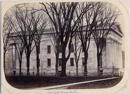
Old Connecticut Statehouse on the New Haven Green. Until 1889, New Haven was the joint state capital of Connecticut with Hartford. The Green played host to a series of statehouses for that purpose. The last statehouse, picture here in 1865, was erected by Ithiel Town in 1837. Yale University Manuscripts and Archives Digital Images Database.
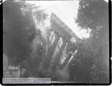
When Hartford was named the sole Connecticut state capital, the statehouse on the Green was demolished in1889. Yale University Manuscripts and Archives Digital Images Database.
The Green has almost always been associated with New Haven’s religious communities. Three churches face Temple Street, which subdivides the Green. The United Church on the Green (Congregational)—also known as North Church—was built in the Federal style by David Hoadley in 1814. The Trinity Church on the Green (Episcopalian) was founded in 1752 and was also designed by Ithiel Town in 1813; it was first identified Gothic Style church in the United States and its crypt was used as the primary burial grounds until the early nineteenth century. The oldest church is the Center Church on the Green (Congregational), first established in 1639. Ithiel Town designed the current Center Church on the Green church in a Georgian style in 1812.
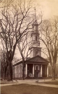
Pictured here is the oldest of the Green’s three churches: Center Church on the Green. First established in 1639, the current structure was built in a Georgian style by Ithiel Town in 1812.1870/1889. Yale University Manuscripts and Archives Digital Images Database.
The Center Church on the Green maintained New Haven first cemetery for decades until overcrowding required a new cemetery to be built on Grove Street in 1797. The crypt at Center Church has preserved some of the original burial sites. Many headstones were moved to the Grove Street Cemetery; most of the bodies, however, remain under the Green, including Benedict Arnold’s first wife, family members of President Hayes, and other founders of Yale University. When Hurricane Sandy knocked over an oak tree in October 2012, a skeleton was found woven among its roots.
Between Temple and Church streets are the Bennett Fountain and the World War I memorial. The Bennett Fountain, designed to resemble the Choragic Monument of Lysicrates in Athens, was built in 1907.. The granite World War I memorial was designed by Douglas Orr in 1928. The Green also contains a Amistad Memorial plaque, at the site of the former jail.
The Green was originally covered by elms – part of the city-wide elm planting funded by James Hillhouse that earned New Haven its name of the “Elm City.” Many of these trees succumbed to Dutch elm disease and in the 1980s the Garden Club of New Haven planted disease-resistant elm trees on the Green and throughout the city.
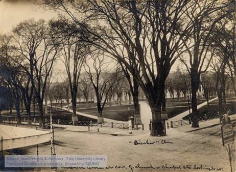
James Hillhouse covered the Green – and a good portion of New Haven – in elm trees, thus earning New Haven the moniker, “Elm City”. Many of the original trees, such as the one pictured here, succumbed to dutch elm disease, but there have been many efforts replant disease-resistant elms.1870/1890. Yale University Manuscripts and Archives Digital Images Database.
In legal terms, the Green is owned privately by the Committee of Proprietors of Common and Undivided Lands in New Haven, a self-perpetuating group of five New Haven citizens who serve for life. Despite the role of the Proprietors, the Green has functioned as a public place for community-building and also social discourse. Every year, the New Haven Green hosts a number of events, such as the Festival of Arts and Ideas and the New Haven Jazz. It has also been the site of rallies and political protest. The Green was designated a National Historic Landmark in 1970.
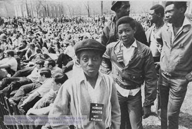
The Green has often been the site of political expression and protest, but perhaps no instance has been so historically significant to the history and identity of Yale and New Haven than the May Day rallies of 1970, pictured here. The May Day rallies were a critique of the Black Panther Trials that were occurring in New Haven. The city was so overrun with protesters that Yale opened its doors to many of them, and classes were suspended for the remainder of the term.Yale University Manuscripts and Archives Digital Images Database.

The Green has also played host to more typical incidents of political expression, such as the 1962 re-election rally for Mayor Richard C. Lee. Lee is the longest-serving mayor in New Haven’s history, serving from 1954 to 1970. He was a leader in New Haven’s post-war urban renewal. Yale University Manuscripts and Archives Digital Images Database.
There are still a number of future challenges that face the Green. The New Haven Green is still seen – by these event organizers and many others – as the place to go if you want your political voice heard. It is a path for political protest –the Green faces both City Hall as well as several major courthouses. The Green is also a place for the community to come together. It is the obvious site for the community to gather after a tragedy. The night of the Sandy Hook shooting, New Haven residents and Yale students gathered for an inter-faith candlelit vigil. The Green itself is the iconic core of the entire city, of course – a statement that the center of a community should be public and shared.
There is not always a consensus about who constitutes the public, however, and who is allowed to share the Green. In 2011, following a global pattern sparked by Occupy Wall Street in New York City’s Zuccotti Park, the Green played host to an Occupy movement encampment. New Haven Occupy “occupied” the Green for six months in 2011-2012. This tent-city raised a lot of discussion about the right to use public space for an extended period of time. Was it within the Occupy Movement’s right to use that space for political protest? With what limits? Did the Occupy encampment restrict the rights of others to use the Green? Or did its presence actually enhance the public functions of the Green? Were nearby residents and businesses inconvenienced? (The Occupiers were often criticized for beating drums and singing long into the night.) The clean-up from the six month encampment cost the city $145,000 – is that a fair price for New Haven taxpayers to pay for others’ political interests? Eventually, the courts ruled that the protest was protected by the First Amendment, but that the city was also constitutional allowed to regulate use of the Green.
The Occupy encampment raised another longstanding issue regarding the Green: homelessness. Some part of the tent-city population was comprised of unhoused people who may have been sleeping on the Green in any event. Occupy New Haven finally came to an end in April 2012 after thirteen final occupiers were arrested and removed from the Green. As a result, New Haven’s Corporation Counsel, Victor Bolden, proposed new rules to clarify use of the Green. The rules formalized the “city’s role in managing use of the Green, which is owned by the private, nonprofit Committee of the Proprietors of the Common and Undivided Lands in New Haven.” The proposal did not allow sleeping or walking on the Green after 10 pm – the same rules for New Haven’s parks. Advocates for the city’s poor are opposed to how this proposal would criminalize homelessness. The Green is a place where the homeless feel safe, exactly because it is a public area. Joseph Foran, a member of the Amistad Catholic Worker House, said the proposal could “fundamentally change the character of the Green, which makes New Haven the beautiful place that it is.” Though the proposal was eventually withdrawn, the consideration of such a proposal demonstrates that the questions of access, equity, and use of urban squares are still very much up for debate. What the exact intended and/or desired use of the Green is will be the greatest question concerning the Green, and other urban squares, in the years to come.
Wooster Square
Wooster Square takes its name from General David Wooster, who owned a warehouse on this location prior to the American Revolution. He was a Yale graduate and successful merchant who died at the Battle of Ridgefield in 1777. Up until 1825, the area that now constitutes Wooster Square was primarily used for ploughing contests.
By 1840, the neighborhood that sprung up around the square attracted New Haven’s most prominent citizens. Over the course of the nineteenth century, the area was settled by the city’s growing Italian community, an affiliation indicated by a bronze statue of Christopher Columbus situated at the southern edge of the square.
The Wooster Square Project emerged in 1958 to help maintain the neighborhood public space. Efforts at revitalization were also led by the Historic Wooster Square Association, Inc. Seventy-two Yoshino Japanese Cherry Blossom trees were planted in 1973 by the New Haven Historic Commission, in collaboration with the New Haven Parks Department and community residents. The annual Cherry Blossom Festival attracts over 7,000 visitors to the square each year.

This projects map from the 1950s was a creation of the City of New Haven Redevelopment Agency. This project map was one of many plans for redevelopment of Wooster Square – partly because Wooster Square had begun to fall into some disrepair, but also as a part of New Haven’s much larger urban renewal of the 1950s and 1960s.Yale Visual Resources Collection.

In 1973, the New Haven Historic Commission planted 72 Yoshino Japanese Cherry Blossom trees around Wooster Square. The annual Cherry Blossom Festival now attracts over 7,000 visitors to Wooster Square each year. Date Unknown. Yale Visual Resources Collection.
These efforts have allowed Wooster Square to flourish in the later part of the twentieth Century and up until today as a place for cuisine (such as the famous Pepe’s and Sally’s pizzerias) and homes of New Haven’s creative class. Since 2004, Wooster Square has also been home to a weekly farmer’s market called City Seed. Wooster Square has become a public space that anchors one of the city’s most distinctive neighborhoods; it is the green centerpiece to a vibrant network of restaurants, cafes, shops, and art galleries. The district surrounding and including Wooster Square earned a spot on the National Register of Historic Place in August 1971.
Future Challenges: In many ways, Wooster Square appears to be the perfect urban square. Many people and groups are dedicated to the square’s success: the City’s Parks and Recreation Department, Wooster Square Block Watch, Friends of Wooster Square, the Downtown Wooster Square Community Management Team, the Historic Wooster Square Association, and many others. The Friends of Wooster Square are currently taking it upon themselves to lead the effort to create a Union Street Dog Park, raising money to install a doggie water fountain and paint the rusted fence – all with the city’s blessing. Could Wooster Square’s greatest challenge be that there are too many cooks in the kitchen? When so many people and organizations are dedicated to the square, there is no clear, primary manager. Or, perhaps more pertinently, because of how much Wooster Square is loved by so many, there could a time when disagreements over use could arise – but they simply haven’t yet. One could imagine a potential future scuffle between merchants and customers at the City Seed Farmer’s Market and the Union Street dog walkers. Do pedestrians or private venders have a greater claim to this private square?
Trowbridge Square
Noted abolitionist Simeon Jocelyn developed Trowbridge Square with the help of architect and builder Isaac Thompson for the purpose of serving as a community space for New Haven’s low-income working-class population. Originally, Trowbridge Square was the center of the Village of Spireworth, laid out by Jocelyn and Thompson in 1830. It was designed to be a miniature version of the city’s original nine-square plan, including “Spireworth Square” as a replica of the Green. Jocelyn was a Congregational minister who was strongly influenced by the “liberal gospel of responsibility” and wanted to provide for the “spiritual betterment” of the city’s African American population. The district surrounding the square was meant to be a model egalitarian and integrated residential community populated by African Americans and whites. The district restrictive the sale of alcohol and banned racial discrimination in an effort to improve the quality of life for the district’s diverse residents. Prior to Jocelyn’s development, the area was known by “Oyster Point Quarter” and was owned by James Hillhouse. Over time, the Village of Spireworth eventually became New Haven’s Hill Neighborhood, a traditional working-class, African American community. The Trowbridge Square Historic District was declared a National Register of Historic Places site in 1985.

This picture shows a view of modern-day Trowbridge Square in the Hill neighborhood. The picture highlights how Trowbridge Square differs from the Green and Wooster in that it is surrounded by much more modest structures and many more purely residential buildings. Date Unknown. Yale Visual Resources Collection.
Future Challenges: Trowbridge Square has not had an easy journey through the ages. Jocelyn imagined an integrated and egalitarian place, but by the 1960s The Hill had grown increasingly into an African-American enclave. Deindustrialization in the 1970s was one case of in increased poverty in the Hill. The square has fallen into disrepair in past years and is sometimes the scene of violence and gang crime; between 2000 and 2012, the Hill neighborhood was witness to 37 firearm homicides (which accounts for 20.5 percent of all of New Haven firearm homicides for that period).
In many ways, Trowbridge Square serves as a foil to Wooster Square. Both were the public center of working-class communities at one point in their history. But while Wooster has become a desirable neighborhood, Trowbridge has grown impoverished and troubled. Despite the challenges that have plagued Trowbridge over the years, there is some indication that the tides may be turning. Trowbridge may have a chance to become a Wooster Square, or at least similarly prosperous. Moves are being made have to return the square to its former glory and to live up to its ambitious founding. For over a decade, the community group Trowbridge Renaissance has tried to “preserve the scale and historic character of Trowbridge Square” by trying to get drugs out of the neighborhood and trying to save many of the historic buildings surrounding the square. Architect and artist Krikko Obbott has just opened the Hill Museum of Arts this January in the hopes to bring art and culture to the neighborhood, as well as provide a space for after-school art programs for Hill neighborhood children. The Winchester Revitalization Arts Projects began hosting the hope-to-be annual “Art in the Square” in 2013.
Trowbridge Square has a long, uphill battle to go before it can hope to fully serve the purposes of a public urban square. Those hoping to revitalize Trowbridge Square will have to overcome the deeply-embedded structures of poverty, drugs, gangs, and crime if they hope Trowbridge Square become an effective – and safe – place for the community to gather.
Preserves, Sanctuaries, and Cemeteries
If urban squares are places for community building, democracy, discourse, or just to see and be seen, then perhaps preserves, sanctuaries, and cemeteries serve an opposite purpose: one of quiet contemplation and peace.
Grove Street Cemetery
Following the yellow fever epidemics of 1794 and 1795, the burial site on the New Haven Green reached its capacity. In 1796, James Hillhouse led the planning effort to find a new burial space on the edge of town. The New Haven Burying Ground – as the Grove Street Cemetery was first called – was organized in 1796 and incorporated in October 1797; the first burial took place in November 1797. The Grove Street Cemetery was the first private, nonprofit cemetery in the world; it was also one of the first burial grounds with a planned layout. Plots are permanently owned by family, but the grounds were also divided to give space to parishioners of the three Churches on the Green, an area for strangers who might die in New Haven, one for the indigent, a section for non-whites, and a section for Yale. In 1821, gravestones from the Green—but not the remains—were moved to the cemetery. In 1848-49, the perimeter of the cemetery was surrounded by an eight foot, brown stone wall.
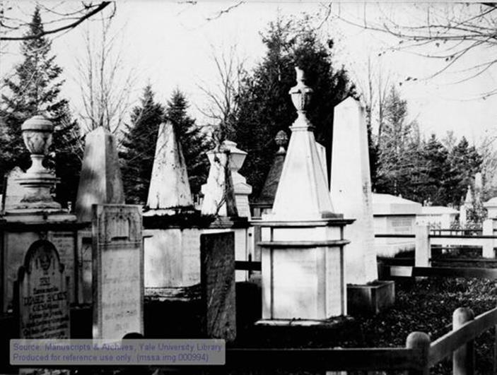
Headstones at the Grove Street Cemetery. Date Unknown.Yale University Manuscripts and Archives Digital Images Database.
Henry Austin designed the Egyptian Revival gateway in 1848, with an inscription from 1 Corinthians 15:52 of the King James Bible: “The Dead Shall Be Raised.” Yale President Arthur Twining Hadley once somewhat jokingly referenced the inscription: “They certainly will be, if Yale University wants this land.” Past the gate is a Victorian chapel, which is presently used as a tour and maintenance office.
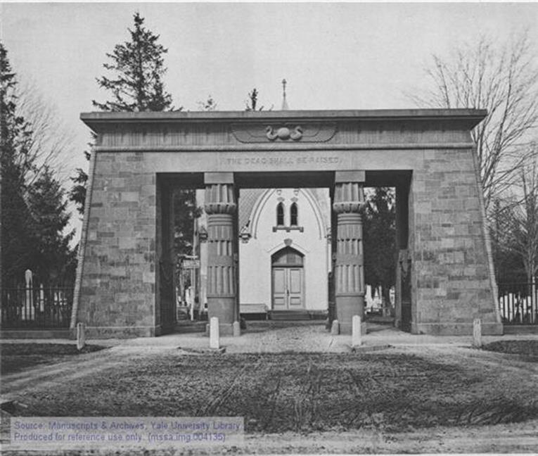
Henry Austin designed the Egyptian Revival gateway, with the inscription “The Dead Shall Be Raised.” Date Unknown. Yale University Manuscripts and Archives Digital Images Database.
The cemetery was originally six acres, but has since been expanded to eighteen. James Hillhouse initially had Lombardy poplars planted within the cemetery, but they succumbed disease in the 1830s. The cemetery now has a more varied array of trees and shrubs. Many prominent people from the history of Yale and New Haven are buried there, Eli Whitney, Noah Webster, Lyman Beecher, and fourteen presidents of Yale. The cemetery is now managed by Camco Cemetery Management and the Friends of the Grove Street Cemetery. The cemetery was added to the National Registry of Historic Places in 1997.
Future Challenges: Perhaps the greatest future challenge facing the Grove Street Cemetery relates to President Hadley’s assertion. For decades, Yale has wanted to build two additional residential colleges. The current plans place the thirteenth and fourteenth across the street and behind the Grove Street Cemetery. With these new colleges being farther from the central campus than the existing colleges, there have been propositions to make the cemetery more accessible for students to pass through from the back to the front gate, as a shortcut to central campus. At a Grove Street Cemetery Proprietor’s meeting in 2009, School of Architecture Dean Robert A.M. Stern proposed a design that would replace a section of the wall along Prospect Street with iron fencing. The proposal was met with a petition of 450 signatures opposing the alterations. Those opposed to the proposal worried that increasing pedestrian traffic would take away from the “peaceful environment of the cemetery.” For those opposed to the project, mourners and respectful tourists are guests that are deserving of the space; students rushing to class are perhaps not.
This proposal brings in a lot of questions about the intended use and access for cemeteries, preserves, and sanctuaries. Should the desires of living pedestrians be valued more than the sanctity of space for the dead? Or should cemeteries, preserves, and sanctuaries be considered the exception to public space: the un-public public space? How does the public – or whoever makes decisions for the public – avoid turning these sanctuaries into just another urban square or park? Does making the Grove Street Cemetery more mindful of pedestrians create a slippery slope for the cemetery down the path of the cemetery on the New Haven Green? Might there be a day when the Grove Street Cemetery’s beautiful headstones are stored in a museum, and the cemetery is just another park with human remains beneath its surface?
Grove Street Cemetery will face other issues in the years to come as well, such as management of limited existing space, how to continually attract visitors to this historic site, and power struggles between the City, Yale, and the Proprietors.
Bishop Woods Bird Sanctuary
Dr. Louis B. Bishop was a successful pediatrician, ornithologist, and charter member of the New Haven Bird Club. He gave up medicine in 1908 to focus solely on ornithology. In October 1928, he donated three parcels of land, along with one owned by his sister’s estate, to the City. The area amounted to 47 forested acres and included the highest point in New Haven east of the Quinnipiac River. Bishop stipulated that “The City will keep this land always as a forest park and bird refuge.”
Over time, the sanctuary fell into disrepair, largely due to the use of all-terrain vehicles (ATVs) and dirt bikes on the grounds. Many New Haven residents did not know of its existence. There was no clear administrative body to advertise the park to potential visitors, and it lacked any sort of signage or entrance to let anyone know it was there.
But in the mid-2000s, the Elm City Parks Conservancy began to turn things around for the sanctuary. The Conservancy believes that “Bishop Woods has the potential to be a refuge from the urban environment, a place where residents can walk and spend time in nature, away from the roars of modern machinery. The place Dr. Bishop envisioned, where the only noises are the sounds of birds and other wild creatures.” By 2006, the sanctuary had been fully embraced once again by the New Haven Bird Club and it was chosen as the location for its Centennial Walk. Further renewed interest in the sanctuary occurred in 2009 with the opening of the new Bishop Woods School. The site is abutted by Bishop Woods School, and the students and faculty take advantage of the wonderful resource right outside their classrooms.

The architectural mock-up design of the Bishop Woods Schools, which abuts the Bishop Woods Sanctuary. A depiction of the sanctuary can be seen in this image behind the school. Because the Sanctuary is not well-known to the public, few pictures of it exist. Date Unknown. JCJ Architecture.
Future Challenges: The greatest challenge facing Bishop Woods Bird Sanctuary is the question of who will take a leadership position to manage and conserve the park. The Friends of Bishops Woods Bird Sanctuary rely on intermittent fundraisers that raise around $600 each time. This fundraising effort is too small to effectively turn things around for the Sanctuary. In the years ahead for the Sanctuary to survive and fulfill its role in the community that it was meant to, some organization is going to need to step up and manage it. The Sanctuary needs to be advertised to the public; much of New Haven is still unaware of its existence. It also needs to be maintained and protected from misuse, such as the ATVs that ravage the land.
There are ecological challenges as well. There has been an increase in condo development at the south end of the Sanctuary. While there have been no plans for the developments to actually encroach on the property, there are concerns that the noise and environmental pollution from construction and residence could disrupt the ecosystem in the Sanctuary. Again, because it is so unclear who is taking a leadership role over the Sanctuary, it is unclear who will fight to protect it from ecological harm.
Yale College
The Collegiate School was founded in 1701 and was then renamed Yale College in honor of Elihu Yale’s donations in 1718. Since its establishment in downtown New Haven, Yale’s campus and open spaces have given New Haven the character of a “college city.” Because of Yale’s iconic architecture, the fabric of the city itself has changed with Yale’s landscaping and architectural forms. As the generator of New Haven’s identity, the Yale campus provides glimpses of outdoor spaces that are carefully designed to give a sense of community, not only for the university but also for the city at large. Not all of Yale’s open spaces are equally accessible to the city at large, however, and even the ones that are may not be particularly inviting. There is a clear distinction between “Yale” spaces, such as Old Campus and Cross Campus, from the city’s open spaces such as the New Haven Green. Nonetheless, the green spaces offer a place for community bonding and a break from urban settings for those in New Haven. The relationship between the people, the school and nature demonstrate how the architectural form and landscape within Old Campus, Cross Campus, and the Yale Fields facilitate the university’s community development while providing a distinct break from the urban environment for the residents of New Haven.
Old Campus
Old Campus is a part of Yale’s original quadrangle building plan, which has a large courtyard connecting several buildings surrounding it. Situated in front of the New Haven Green and enclosed by College, Elm, High and Chapel Streets, Old Campus has a green courtyard in the middle with rows and columns of trees and many different pathways that radiate from all sides of the quadrangle, some originating from Phelps Gate and some from the High Street gate. Based on the “Old Brick Row” plan, which consisted of a single row of Georgian and brick buildings that were constructed at the edge of the New Haven Green during the eighteenth century, the design towered over religious and academic halls facing the New Haven Green. By the nineteenth century, the new construction of large stone buildings removed the “Old Brick Row” that was initially open to the city.

Obscured by the construction of large stone dormitories that seemed to form a fortress, Old Campus began to turn inward onto the green courtyards. Incrementally, Old Campus began to physically separate the university from the city. This change prompted Yale students to use the central open space for community-building activities, fulfilling the goals of its designers.
Built in 1895 by Charles C. Haight, Phelps Gate is the entrance to Old Campus at the head of the New Haven Green. Phelps Gate is an arched entryway that cuts under Phelps Hall, a heavy, neo-Gothic structure, which opens to the enclosed yet flowing open space. Directly in front of Phelps Hall on Old Campus, Yale’s second oldest building stands. As the first building designed in the Gothic Revival Style, Dwight Hall faces inward toward the courtyard. Originally built as a library, the wood detailing inside highlights the intricate craftsmanship of the designer Henry Austin. Phelps Gate is an important structure because it provides a gateway and a physical connection between Yale and New Haven. The main gate to Old Campus for visitors to the university is Phelps Gate, as it offers open access to Old Campus for the New Haven residents from College Street (where the New Haven Green is also located). As such, many visitors and Yale students frequently use this area to enter and exit the University.

Created by John Phillips in 1942, this photograph can be found in the Manuscripts and Archives of Yale University under the Record Unit named Pictures of student life at Yale, 1779-1988 (inclusive). This picture shows fine details of the archway and the gate that opens up to Old Campus.

This building was taken in 1860s according to the Yale Manuscripts and Archives Database. This structure is the first building that one can see from the Phelps Gate. This building is now called the Dwight Hall.
Today, Old Campus is home to most freshmen undergraduates and serves as an iconic green space for the university. Seven residence halls form the quadrangle, Lanman-Wright, Durfee, Farnam, Lawrance, Welch, Bingham, and Vanderbilt. The long, narrow wooden buildings that served as the dormitory, chapel, classroom, library, and dining hall during the 18th and 19th centuries, once occupied present-day Bingham Hall, located at the corner of College and Chapel Streets. Likewise, Old Campus encompasses various historical statues such as those of Rector Abraham Pierson, Nathan Hale, and Theodore Dwight Woolsey. These historical references found within Old Campus create a sense of Yale identity by reminding people of Yale’s origin and its history.
Old Campus, because of its Gothic architecture, embodies the history of the school. The open space in the middle is defined by a row of Georgian buildings and accompanied by some other brick buildings. One of these buildings, Connecticut Hall, stands in front of Welch Hall.

This picture shows Connecticut Hall with students sitting in the windows. Found in the Pictures of Connecticut Hall, Yale University, 1753-2000 (inclusive) folder within the Manuscripts & Archives of Yale University.
Built on a site parallel to the street separating the University from the New Haven Green in 1750 by Francis Letort and Thomas Bills, Connecticut Hall is the oldest standing building at Yale. This structure was the first building of an ensemble known as the “Old Brick Row.” This building has transformed from a dormitory into a historical monument. What used to be student rooms are now faculty offices and seminar rooms for the Philosophy Department. This building reminds passerby that Yale University’s community began within this structure; students acknowledge this place as the first residence of Yale. As such, Connecticut Hall reinforces the importance of community buildings processes that would occur on Old Campus.
The enclosed courtyard and the inward-facing outer row of buildings that compose Old Campus create a division between the city and the University. Nonetheless, this division has also created a new type of urban space for New Haven residents. Old Campus green courtyard serves as another urban space such as parks. Typical urban park designs incorporate grass and trees into their landscapes. These qualities are definitely reflective in the design of the courtyard of Old Campus. Therefore, as a historic site with green landscape, Old Campus provides another such “park” setting for New Haven residents. When Phelps Gate is open, there are enough benches and green space for New Haven residents to participate in a variety of activities.
In order to create a public space that reflected the inherent social diversity of the school and the surrounding neighborhoods, the green space was created to provide a place of community. To Yale students, the courtyard of Old Campus has become synonymous with community and identity. Students often spend their time on Old Campus playing various sports and hosting events. Likewise, Old Campus provides a place for New Haven residents as an urban “park” that is somewhat removed from the cityscapes within the downtown area. The New Haven Green is easily accessible to the people of New Haven and is one of the biggest green squares. However, Old Campus provides a different type of space for New Haven residents to enjoy a separate set of historical aspects and aesthetics found within its architecture. In conclusion, Old Campus has effectively cultivated a sense of community with its green space in the middle despite Old Campus being not technically a public space because it is on Yale’s grounds. However, it still serves as a vital social infrastructure as well as an environmental infrastructure for the city.
Looking ahead in the future, there may be some conflicts between New Haven residents from the students of Yale University about the usage of Old Campus as an urban “park”. This conflict is inevitable because the question of public verses the private space becomes evident in this situation. Old Campus is regarded as a private space to Yale students while it may occur to other people as a public space in a sense that they have easy access to it during the day when the Phelps Gate is open. Despite the conflict, the trend we see here is the publicizing of private spaces. In the future, the administration of Yale University and the city officials should discuss the implications of publicizing the private spaces and decide whether or not people can continue to use Old Campus as an urban “park”.
Cross Campus
Between Wall and Elm Street, stretching from Sterling Library to College Street, what used to be a walkway called Blount Avenue is now the current day Cross Campus. Continuous architectural composition from Sterling Library to Calhoun College creates a linked space that allows students to simultaneously experience the buildings and the openings between them. Berkeley and Calhoun Colleges along with William L. Harkness Hall frame the open space, and the open space is the green space in the middle. Embodying and sharing beautiful architectural aspects similar to those on the buildings on Old Campus, the buildings on Cross Campus exude a historical feel as well. Because it is not an enclosed space, Cross Campus can provide a sense of visual coherence without changing much of its architectural form. Cross Campus is different from Old Campus in this aspect because no gates bound Cross Campus; there are no gates that open and close regularly like Phelps Gate. Cross Campus is an open green space that is also accessible to non-Yale students.

In the picture, Berkeley College is North on the left. William L. Harkness Hall is on the right, and University Dining Hall (Commons) in the background. This image was found in Yale events and activities photographs, 1852-2003 (inclusive) folder within the Manuscripts & Archives, Yale University.

Architectural drawing of Berkeley College. This photo was found within the Photographs of Berkeley College, Yale University, 1933-1997 (inclusive) folder at Yale University’s Manuscripts and Archives.
As another symbolic green space at Yale, Cross Campus boosts diversity and a sense of community with its architecture and its design. Both Yale students and New Haven residents can use this space as an urban “park”. There are benches on the perimeters of the grassy areas and an open grass yard for activities such as sports and picnics. The visual and sensual experience of this green space is very similar to those experienced at a park because greenery and flowering plants and trees form the background landscape of Cross Campus. Taking a walk through the area also offers a feeling of walking through a trail within a park because of the lining of the trees. Because of the continuous flow of activities that occur on Old Campus, a simple walk through its perimeters will be enough to facilitate sensations of diversity and community.
For New Haven residents, Yale courtyards provide an excellent avenue for social gathering in a non-urban setting; or in other words, they provide an escape from the city. The New Haven Green has been the cultural and social center for the city of New Haven for a while now. However, the city had not yet seen an open green space like Cross Campus that was connected to but separated itself from its urban surroundings. Certainly, by taking a break and taking a walk through Cross Campus, New Haven residents can enjoy a new setting in which they are removed from the hustle and bustle of the urban life.
In the end, the conversation about the private verses the public spaces happen in this case as well. Again, the role of university as a creator of these open spaces is instrumental in promoting the social and community developments for the students at Yale as well as the residents of city of New Haven. Many of the residents walk or run through Cross Campus by themselves or with their pets like a typical park. In a sense, the most community bonding occurs during these instances. However, there has not been a conflict in which the residents were forced out of these spaces, but it may be a possibility in the future, not because Cross Campus is not open to the public, but because it is indeed a private space that is owned by Yale University. Nonetheless, one cannot overlook how important these open spaces are as a vital social infrastructure for the development of one community.
Yale Fields
Yale has a long history of outdoor athletics and the Yale Fields have been a great resource for the city at large. Located three miles west of campus are the principal outdoor athletic facilities and the Yale Golf Course. College sports and its associated traditions were largely developed at Yale and have thus been incorporated into the lives of many New Haveners. Beginning with the first rowing races in the New Haven Harbor in 1843 and due to the fact that New Haven has no professional sports teams, Yale’s athletic teams have also come to symbolically represent New Haven. As such, residents of New Haven follow the schedules of Yale’s football, hockey, basketball, squash and various other teams. However, perhaps Yale’s greatest sports-related contribution to the city has been with respect to the establishment of the Yale Bowl along with a large set of buildings and athletics fields. These green spaces and facilities attract students and New Haveners alike because they serve as a refuge from the city for the fans of Yale Athletics.
Along with a sequence of parks and cemeteries that emerged along the West River under the guidance of Donald Grant Mitchell in the 1890s, the Yale Fields, augmented by the land occupied by the Yale Bowl and the Yale Golf Course, proved to be an attractive, stable asset. In 1914, the Yale Bowl was completed, which was one of the largest amphitheaters to be constructed since the Roman Coliseum. Charles A. Ferry, Class of 1871, proposed the design for the Bowl. Nearly thirty miles of wooden-backed seats were put in place to build the 30 feet-high walls designed to support the top rows of seats. This magnificent structure was the main venue for the 1995 Special Olympic World Games and the Giants’ games in 1973 and 1974. Located on the Derby Avenue of the New Haven-West Haven border, the Yale Bowl is the principal facility of the Yale athletic complex. Across the street is Yale Field, home to the Yale baseball, tennis, track and field, and lacrosse teams.

This image captures the entirety of the Yale Fields. With the Yale Bowl on top of the image, the grand design of the Yale Fields welcomes both Yale students and New Haven residents. This picture was taken in 1931 and can be found in the Yale Manuscripts and Archives Database.
The fields offer a sense of community in a way that unites the supporters of Yale Athletics. The fans, both Yale students and New Haven residents, visit and use these spaces, and both Yale students and New Haven residents identify with the athletics teams of Yale. Therefore, the fields provide a closer connection for Yale students and New Haven residents than the fields found in a park. This common identification as fans of Yale Athletics brings the community together and allows them develop stronger ties with Yale University and the city at large.
One of the other most famous green fields of Yale University is the golf course called the Course at Yale. Charles Blair Macdonald designed the Course at Yale in 1926. Sarah Wey Tompkins donated the land to Yale in memory of her husband Ray, football captain of the 1882 team. This New England-style golf course is one of the most historic golf courses in the country with spectacular mountain views, rolling terrain, and large greens, spanning a total of 700 acres. In particular, this golf course is considered one of the best collegiate courses in the country. With its intricate design and artful integration with the natural landscape, the terrain features many hilly, rocky, and undulating holes. This green space definitely blends in well with the surrounding forest; as such, the scenic course attracts golfers from around the world because of its beauty and unique style. Ultimately, the course provides a welcome respite from the hustle and bustle of downtown New Haven and gives Yale-associated personnel and the public a place of getaway. The golf course is very different from the urban green spaces such as the New Haven Green in a way that it is about 4 miles away from the downtown area. With serenity and tranquility radiated from the woodlands that surround the golf course, the Course at Yale offers an alternative experience from the busy downtown area of New Haven and Yale University.

Showing all 18 holes of the Course at Yale, this shows how much greenery is incorporated into the design of the golf course. As one can see, the golf course is removed from the central downtown area of New Haven. Because it is in the middle of the woodlands, it can be the best getaway from the city.
In conclusion, the Yale Fields provided a social infrastructure for the city at large. Even though these fields were managed by the Yale Athletics Department, the use of these spaces from a fan’s perspective did not become privatized. For the most part, the “public” spaces (because they are open to the public) seemed to have provided a great sense of community and an improvement for both of the communities, Yale and New Haven. There is no trend toward the privatization of these “public spaces” because Yale will always have these fields open to the general public for the benefit of both the department and the fans.
Community Gardens
Green spaces play a crucial role in supporting urban ecological and social systems. Playing the ecological function in urban environments, community gardens and its green spaces can offer broader social benefits as meeting places that give a shared focus to community development. Green spaces like community gardens are extremely important in supporting urban community both ecologically and socially. Ultimately, community gardens can provide community integration in a way that private gardens cannot. These social interactions in community gardens are focused around a network of people within the communities. By looking at the impacts of open spaces in urban landscape such as community gardens, the importance of open green spaces can be recognized.
In terms of New Haven, there are several programs that can be found within the parks that create an open green space for the public. Greenbrier Greenhouse and Crosby Conservatory is a vocational program run by Easter Seals. This greenhouse and conservatory located in Edgerton Park. The green house sells seasonal plants year-round features a children’s corner for young horticulturists, and sponsors activities for the New Haven schoolchildren. In addition, Pardee Rose Garden is also a garden that is found within a park. Located at the intersection of Park Drive and Farm Road, this garden is 2 acres in size and contains an array of flowers. Established in 1922 with a gift of William S. Pardee, this garden also provides a social space for the citizens of New Haven. These spaces have been instrumental in promoting a sense of community and a place of serenity. Not only these gardens creating a social environment for children and adults, but also, they are maintaining the ecological and environmental infrastructure for the city.
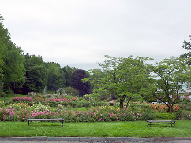
This beautiful garden has a variety of flowers and an open space for the public to enjoy. This image was found on the Department of Parks, Recreation and Trees website within the City of New Haven website. Source: http://www.cityofnewhaven.com/Parks/gardens/ pardee.asp.
Like the gardens within parks, the community gardens found within the neighborhoods also provide a place for social interaction. For example, there is the Bioregional Garden in the East Rock area. As a part of the New Haven Land Trust, this community garden shows the interaction of human society with natural systems. By promoting a community gardening processes, this public garden encourages individuals to come and develop the garden. There is also another public community garden that was designed specifically for children. Called as Davenport Children’s Garden, this community garden focus on children’s programs, making sure that this site is suitable for social interactions.
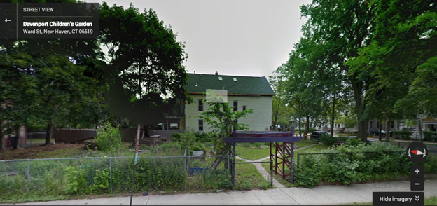
This google street image of the garden shows the open nature of the public community gardens. With the wide-open gate, this place only serves children.
Used often by community as a park, this garden is designed and constructed by the children who use it. Located in the Hill Neighborhood, it is one of the popular social spaces for children in the area. Another community garden called Green Garden of Hazel Street show how revitalization to an urban setting could occur in the context of community gardens. Alonzo Bryan is the main operator of this place, and he defines this community garden as an urban farm. The food produced in the garden goes to local residents and institutions in the Newhallville neighborhood.
With these community gardens as urban, public spaces, many people utilize these spaces for personal benefits. However, to what extent should these spaces be monitored and managed by one person verses the community as a whole? Even though these gardens can be a social and an environmental infrastructure for the neighborhood, one vital role that these urban spaces play is providing space for the expression of diversity within the community. The access to these gardens is open to all people; however, the role of these gardens as public space may need to reconsideration because a person regulates it. Even though it is a public space, the management of the gardens does not apply to the entire community. This nature suggests that the urbanity of public open spaces is threatened by the increase in demand of people wanting to be in charge of community gardens. Enhancing the use of public gardens and creating a community management program, the overall experience of community gardens will become more fruitful.
Bibliography
Appel, Allan. “Answers Found In The Park”. New Haven Independent. http://www.newhavenindependent.org/index.php/archives/entry/answers_found_i n_trowbridge_square_park/ (Accessed February 11, 2014).
Appel, Allan. “God Might Return to Trowbridge Square.” New Haven Independent. March 23, 2010.
Appel, Allan. “More Condos Slated for Weary Bishop Woods.” New Haven Independent. May 11, 2011.
Benoit, Cordalie. “A Message from the President.” Elm City Parks Conservancy. http://www.cityofnewhaven.com/parks/images/ecpc/pdfs/Newsletter- summer07.pdf (Accessed February 11, 2014).
“Bioregional Garden.” New Haven Land Trust.
http://www.newhavenlandtrust.org/gardens/ bioregional-garden
“Bishop Woods – Centennial Walk – November 26, 2006.” New Haven Bird Club. http://www.newhavenbirdclub.org/bw.htm (Accessed February 11, 2014).
Brown, Elizabeth Mills. New Haven: A Guide to Architecture and Urban Design. New Haven: Yale University Press, 1976.
Chinapen, Rachel. “Song filled rally on New Haven Green celebrates withdrawal of ordinance proposal.” New Haven Register. February 14, 2011.
The Course at Yale and Maltby Lakes Recreation Area.” Yale Bulldogs. http://www.yalebulldogs.com /information/facilities/course_at_yale/index
The Course at Yale. http://thecourseatyale.org/index.html
“Davenport Children’s Garden.” New Haven Land Trust. http://www.newhavenlandtrust.org/gardens/ davenport-childrens-garden
“New Bishop Woods School Opens.” City of New Haven. http://www.cityofnewhaven.com/Mayor/Promo/ReadMore.asp?ID=%7BE537A15 C-CF0F-4AF1-9E3C-72886CF42796%7D (Accessed February 11, 2014).
“Green Garden of Hazel Street.” New Haven Land Trust. http://www.newhavenlandtrust.org/gardens/green-garden-hazel-street.
“The Grove Street Cemetery.” Grove Street Cemetery. http://www.grovestreetcemetery.org/ (Accessed February 11, 2014).
“The Hill Museum of Arts.” Krikko Productions. http://krikkoproductions.com/hill- museum-of- arts-i-7.html (Accessed March 3, 2014).
“History.” CitySeed. http://cityseed.org/about-cityseed/history (Accessed February 11, 2014).
“National Register of Historic Places Inventory-Nomination Form: Village of Spireworth/Mount Pleasant.” United States Department of the Interior National Parks Service. http://pdfhost.focus.nps.gov/docs/NRHP/Text/85002311.pdf (Accessed February 11, 2014).
“New Haven Green.” National Park Service. http://www.nps.gov/nr/travel/amistad/gre.htm (Accessed February 11, 2014).
“New Haven Green.” TownGreens.com. http://www.towngreens.com/greenlink/index.cgi/view/58 (Accessed February 11, 2014).
“New Haven Green Historic District.” National Historic Landmarks Program. http://tps.cr.nps.gov/nhl/detail.cfm?ResourceId=1022&ResourceType=District (Accessed February 11, 2014).
New Haven Police Department. 2012. New Haven Crime Incidents 2000-2012.
O’ Leary. Mary E. “Plan for New Haven Green rules riles advocated for poor.” New Haven Register. January 12, 2014.
Pinnell, Patrick. Yale University: an architectural tour. New York: Princeton Architectural Press, 1999.
Sanders, Alexander. “Occupy New Haven encampment cleared out; 13 protesters arrested.” New Haven Register. April 18, 2012.
Sexton, James. “Not a Park or Mere Pleasure Ground: a Case Study of the New Haven Green.” TownGreens.com. http://www.towngreens.com/DOCUMENTS/tg_newhaven_case.pdf (Accessed February 11, 2014).
Sherman, Joy. “Andean Evening to Benefit Bishop Woods.” Elm City Parks Conservancy. http://newhavencity.webship.com/Parks/images/ecpc/pdfs/Newsletter- summer05.pdf
Spencer, Thomas and John J. Russell. Gardens across America: The American Horticultural Society’s Guide to American Public Gardens and Arboreta. Lanham: Taylor Trade Publication, 2005.
Taylor, Frances Grandy. “Grove Street Cemetery At Yale Becomes U.S. Landmark Today.” The Courant. http://articles.courant.com/2000-09- 23/news/0009230035_1_burial-ground- grove-street-cemetery-landmark-today (Accessed February 11, 2014).
“Trowbridge Square Historic District.” CT Freedom Trail. http://www.ctfreedomtrail.org/trail/concept-of-freedom/sites/#!/trowbridge-square- historic-district (Accessed February 11, 2014).
“Trowbridge Square Historic District.” The New Haven Preservation Trust. http://nhpt.org/index.php/site/district/trowbridge_square_historic_district(Accesse d February 11, 2014).
“Union Street Dog Park News!” Friends of Wooster Square. http://www.friendsofwoostersquare.org/dog-park.html (Accessed March 3, 2014).
“Welcome to the Pardee Rose Garden.” Welcome to Department of Parks, Recreation and Trees. http://www.cityofnewhaven.com/Parks/gardens/pardee.asp.
“Wooster Square History.” Historic Wooster Square Association, Inc. http://www.historicwoostersquare.org/(Accessed February 11, 2014).
“Wooster Square Historic District.” The New Have Preservation Trust. http://nhpt.org/index.php/site/district/wooster_square_historic_district/ (Accessed February 11, 2014).
“Yale Bowl, Class of 1954 Field.” Yale Bulldogs.
http://www.yalebulldogs.com/information /facilities/yale_bowl/index
Wilcox, Stephen. “A Message from the President.” Elm City Parks Conservancy. http://www.cityofnewhaven.com/parks/images/ecpc/pdfs/Newsletter-fall04.pdf (Accessed February 11, 2014).
Zhang, Baobao. “Residents debate Grove Street Cemetery wall.” Yale Daily News. October 7, 2009.