Julian Sagastume
In Nature’s Metropolis, William Cronon uses the term “second nature” to refer to physical and economic alterations in the landscape that mediate our understanding of it. Whereas earlier societies might have organized their world in terms of natural boundaries such as rivers, mountains, forests–first nature–ours is a society of railroad lines, neighborhoods, parks, and subway stops. The networks and environments once meticulously debated, planned, and constructed become the taken-for-granted, the static, the neutral: “Despite the subtly differing logic that lay behind each, the geography of second nature was in its own way as compelling as the geography of first nature, so boosters and others often forgot the distinction between them.” [i] Human beings adapt to places as the find them and so too often, we fail to properly interrogate the ground beneath our feet. The purpose of this People’s Guide is to engage in some of this much needed interrogation–to attempt to answer fundamental questions about New Haven’s networks and structures that are often taken for granted in an effort to understand the ways in which they mediate everyday life. My purpose in this afterword is to provide a brief overview of these questions as well as propose a new question to be asked by all those who engage with infrastructure: who benefits?
Infrastructural Regimes
Though often viewed as static, a city’s infrastructure network constantly morphs and bends to the forces of technological and social change. In the history of New Haven, periods of rapid technological change have remade the fabric of the city on numerous occasions, each time reflecting new norms and priorities, and benefitting different groups. When railroads and streetcars arrived in the 19th century, for instance, the city grew in population and geographical size—with more people than ever counting themselves as New Haveners. These public transportation lines made the city’s downtown easily accessible and emphasized development within the reach of the network. Streetcar suburbs such as Fair Haven, West Haven, and Newhallville emerged as the dominant housing paradigm for the city’s working class. However, when the automobile became popular in the 20th century, the city remade itself again, this time prioritizing regional interconnectedness. Far-flung towns such as Hamden, Orange, and Guilford suddenly found New Haven within reach. This accessibility, however came at the expense of the old streetcar suburbs, which were left to decay as residents fled to the suburbs.
Indeed, a dramatic expression of the New Haven’s new regional priorities, in 1957, plans were drawn to demolish the poor Oak Street neighborhood to make way for the Oak Street connector, a highway project which would have linked I-95 to the Merritt Parkway. In addition to devastating local communities, the demolition dramatically altered the landscape of the city, sequestering Long Wharf and the Hill from downtown.

Oak street area before and after the construction of the connector. The introduction of the automobile dramatically altered the landscape of the city. What before was a dense, populous neighborhood was destroyed for a connector that primarily served suburban commuters. (c. 1960) Source: Yale University, Yale and New Haven Digital Collection.
Improvements in technology (the automobile) and changes in the social landscape (suburbanization) had brought forth a new infrastructural regime—one that served some residents well, but left others, such as the residents of Oak Street, behind. Indeed, with every new infrastructural development there are winners and losers: with the introduction of the Internet, local newspapers across the country have experienced precipitous decline, while blogs such as the New Haven Independent have come to occupy the niche once held by reporters at local publications. Historically, when water and sewer networks first came to the American city, individuals who had once provided for their own hygienic needs experienced a loss of autonomy, while private utility providers reaped ever-greater profits. [ii] The development of alternative energy resources certainly helps the environment and help, but at the expense of the petroleum industry which uses the Port of New Haven as a major node in its distribution network. In every era, new technologies constantly remake the fabric of a city, but the new metropolis that results does not always benefit all parties equally.
Today, the City of New Haven is undergoing another period of rapid transformation. After decades of industrial decline, the city’s population grew by 5 percent between 2000 and 2010. Indeed, current projections suggest that the city will match or beat that rate of growth every five years until 2025, outpacing any other city in the state of Connecticut.
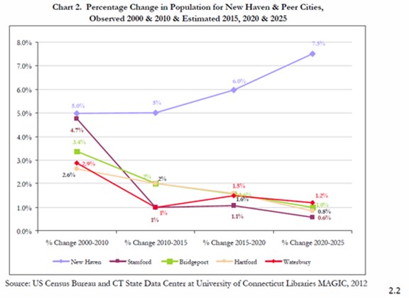
Percentage Change in Population for New Haven and Peer Cities. Source: City of New Haven, Comprehensive Plan Update.
This rapid growth in population will test the infrastructure of a city with the lowest housing vacancy rate in the nation. Furthermore, this population growth brings with it new patterns of living and moving: between 2000 and 2010, bicycle and pedestrian traffic congestion at peak times increased 45% and 95% respectively in the New Haven region while vehicle miles travelled increased only 1.8%. [iii] Certainly, the city will need to act in order to support this population increase and changing attitudes towards mobility. It will need to construct more housing, improve diverse transportation services—pedestrian, bicycle, transit, and automobile-based—and increase capacity on data and energy networks. However, as the city remakes itself for a new population, lines will need to be redrawn and priorities decided. The fundamental question is: who benefits?
For instance, in 2008 when the City of New Haven performed a feasibility study regarding the construction of a downtown streetcar system, the chosen route connected Union Station to the Peabody museum, passing through the highly walkable Church Street corridor which runs past City Hall and Yale’s campus.

New Haven Streetcar Proposal. The streetcar would have connected a number of landmarks in the city’s downtown, but did not touch outlying neighborhoods. Source: Data Haven.
Why did the city choose to study this corridor over other more heavily trafficked corridors? Would it have made more sense to follow the route of the D or Q busses, New Haven’s most heavily used public transportation routes? Though city planners take a number of factors into account when considering new projects, the lesson of the New Haven Streetcar is that in a city with growing infrastructural challenges and finite resources, hard decisions must be made about which neighborhoods and populations to serve first. Infrastructure not only connects, but also divides, drawing distinctions between neighborhoods and population groups.
Our duty, then, is to ask this question of every new proposal that comes before the city: who benefits? Will high-speed rail proposals along the northeast corridor create benefits for the entire city, or merely privilege a select few business travellers? Will the introduction of sustainable energy into the power supply cause a price increase that hurts low-income consumers, or are the benefits of clean air and water worth that increase? Are bike lanes, a favorite initiative of New Haven’s young urban professionals, really the right solution for the city’s working class, or should we instead look to broaden streets? In each of these scenarios, the act of balancing harm and benefit is of critical importance. In the past, we have too often allowed the perceived long-term benefits of a project (such as the oak street connector) to obscure the importance of protecting local communities. By interrogating the ground beneath our feet, we can help to protect against this sort of hubris.
The Private and the Public
One major dimension of the infrastructural divide in New Haven lies between the public and the private. In New Haven, national trends of declining industry and growth in the education and healthcare sectors have manifested themselves in Yale University, which continues to grow in importance and geographical footprint relative to its home city.

This map of the University in 1901 shows its limited footprint relative to the surrounding city. Though central, Yale remained a marginal power in the city relative to its neighborhoods and manufacturing firms. Source: Yale University, Y Design.

By contrast, this map shows Yale’s footprint in New Haven in 2000. The university, now an integral part of New Haven’s economy, continues to expand to the north and south. Source: Yale University, A Framework for Campus Planning (2000).
Though Yale played a vital role in the stabilization of its home city starting in the early 1990s, creating programs such as the New Haven Homebuyers Program, Office of Cooperative Research, Local Purchasing Initiative, and Yale Properties to remake the city’s economy and spur redevelopment [iv], these initiatives have also caused the University to grow relative to New Haven. Yale-New Haven Hospital is currently the city’s largest employer and Yale University itself is a close second. This growth has caused political problems for the city government, since Yale University, as a nonprofit, does not pay property taxes, but has also changed the nature of the city itself: as the university has grown, so has an infrastructural divide between its campus and the city. Indeed, as the university continues to expand, with two new residential colleges slated to begin construction this year, we should continue to ask that fundamental question: who benefits?
The Yale-New haven infrastructural divide takes many forms, articulated throughout this guide. In the area of public space, with the construction of the residential colleges in the 1930s, for instance, formerly publicly accessible courtyards became sealed off—making what was once public space private. In the area of energy, Yale maintains its own separate electrical grid, operating two state of the art tri-generation power plants and a steam-driven heating system separate from the aging local plants that power the city. This means that the electricity that serves New Haven residents has a much higher carbon footprint than the electricity that serves Yale and often, when New Haven loses electricity, Yale does not. And in the area of transportation, Yale maintains its own private, free shuttle system that often makes Yale students reluctant to use local public transportation. For all the good that Yale’s expansion has done for New Haven, the university has also, intentionally or not, created an infrastructural divide between itself and its home city. As Yale continues to grow, we should continue to question this divide.
Ought Yale privatize its power plants and allow them to produce clean power for the entire city? Ought it distribute local transit passes to its students (as many urban universities do) [ix] rather than maintain a separate shuttle system? As it pursues more development, ought it ensure that the housing it builds is inclusive and affordable? An informed, passionate public, can pressure the university to answer these questions with fairness in mind.
Conclusion: The Networks that Connect
The People’s Guide to New Haven infrastructure is an imperfect taxonomy—there is no way to completely catalog the entire infrastructure of any city, even one as small as New Haven. Its purpose, then, is not so much to exhaustively inform, but to inspire. Though infrastructure networks often become “second nature,” their seeming static character belies a more complex history. Over the four centuries of its existence, New Haven has experienced a number of periods of rapid technological change that have reshaped the fabric of the city—serving certain populations well, and others poorly. Today, the city is in yet another period of rapid change: a growing population more friendly to walking, biking, and public transit, a push for sustainability, rapidly changing communications technologies, and a revolution in thinking regarding public space, are changing in cities in ways that are difficult to understand. Even huge projects, such as the Oak Street Connector are not immune from change: starting in 2013, the Downtown Crossing redevelopment project has sought to repair the damage caused by the connector. The project seeks to reconnect the cities downtown to neighborhoods such as The Hill and Long Wharf, while creating new spaces for businesses looking to relocate downtown. In addition to reconnecting the city, however, Downtown Crossing, like all infrastructure also has the capacity to divide. Will the elimination of traffic-carrying capacity make it more difficult to get downtown? Will increased connectivity cause more wealthy New Haveners to move south, pushing residents out of neighborhoods in the Hill?
The answers to these questions lie beyond the scope of this guide, but not beyond the scope of the authorities who plan for the city’s future. To make sure these authorities consider equity, history, and community in their plans, an informed public is vital. As the city continues to remake itself, we must remain cognizant of the networks that connect and divide. Rather than taking infrastructure for granted—rather than treating it as an extension of nature—we ought to interrogate the ground beneath our feet.
Bibliography
[i] Cronon, William. “Rails and Water.” Nature’s metropolis: Chicago and the Great West. WW Norton & Company, 1992. 55-96.
[ii] You know the article.
[iii] City of New Haven. “Introduction.” Comprehensive Plan Update. December 2013. http://www.cityofnewhaven.com/cityplan/pdfs/Draft%20Databook%20Narrative/Chapter%20I.pdf (accessed April 26, 2014).
[iv] Prevost, Lisa. “Developer Takes a Look at Downtown New Haven.” New York Times, February 11, 2014. http://www.nytimes.com/2014/02/12/realestate/commercial/a-stretch-of-downtown-new-haven-gets-a-second-look.html (accessed May 1, 2014).
[v] City of New Haven. “Transportation.” Comprehensive Plan Update. December 2013. http://www.cityofnewhaven.com/cityplan/pdfs/Draft%20Databook%20Narrative/Chapter%20VI.pdf (accessed April 26, 2014).
[vi] Levin, Richard C. “Beyond the Ivy Walls: Our University in the Wider World.” The work of the university. Yale University Press, 2003. 6.
[vii] City of New Haven. “Economy.” Comprehensive Plan Update. December 2013. http://www.cityofnewhaven.com/cityplan/pdfs/Draft%20Databook%20Narrative/Chapter%20VII.pdf (accessed April 26, 2014).
[viii] “Project Overview.” Route 34 New Haven Downtown Crossing -. http://downtowncrossingnewhaven.com/overview/ (accessed May 1, 2014).
[ix] “U-Pass.” Streetsblog Chicago. http://chi.streetsblog.org/tag/u-pass/ (accessed May 1, 2014)